

Sheldon Creek Neighbourhood Traffic Management
The City of Burlington has retained CIMA+ to conduct a Traffic Management Study for the Sheldon Creek Neighbourhood. The study area is bounded by Appleby Line in the west, Upper Middle Road in the north, Mainway in the south and the Sheldon Creek Naturalized Area in the east. The purpose of the study is to review traffic, speeding and parking issues within the neighbourhood in a holistic manner, engage with the public and identify traffic calming and parking management solutions to address the identified issues.
The City of Burlington has retained CIMA+ to conduct a Traffic Management Study for the Sheldon Creek Neighbourhood. The study area is bounded by Appleby Line in the west, Upper Middle Road in the north, Mainway in the south and the Sheldon Creek Naturalized Area in the east. The purpose of the study is to review traffic, speeding and parking issues within the neighbourhood in a holistic manner, engage with the public and identify traffic calming and parking management solutions to address the identified issues.
Sheldon Creek Neighbourhood
Sheldon Creek Neighbourhood Residents,
If you have any questions regarding the Traffic Management Plan, you can email Chris King or Eric Bentzen-Bilkvist directly or fill out the Question & Answer form. Your question will be answered, and both the question and response will be visible on the Get Involved Burlington webpage for yourself and other residents to see.
-
Share Is the Sheldon Creek Neighbourhood engagement survey still open? If yes, where is it located? Is there a status update on the street parking plans that were proposed during the March 2023 presentation? Thanks. on Facebook Share Is the Sheldon Creek Neighbourhood engagement survey still open? If yes, where is it located? Is there a status update on the street parking plans that were proposed during the March 2023 presentation? Thanks. on Twitter Share Is the Sheldon Creek Neighbourhood engagement survey still open? If yes, where is it located? Is there a status update on the street parking plans that were proposed during the March 2023 presentation? Thanks. on Linkedin Email Is the Sheldon Creek Neighbourhood engagement survey still open? If yes, where is it located? Is there a status update on the street parking plans that were proposed during the March 2023 presentation? Thanks. link
Is the Sheldon Creek Neighbourhood engagement survey still open? If yes, where is it located? Is there a status update on the street parking plans that were proposed during the March 2023 presentation? Thanks.
smokey17 asked almost 3 years agoSheldon Creek’s NTMP engagement survey period has closed. A final report is in the process of being finalized by City staff and the consultant CIMA+. Once it is completed, information will be provided on the Sheldon Creek Get Involved Page. Feel free to subscribe to the project page so that you will receive emails as new arises.
-
Share Where is the slide presentation from the second virtual PIC? on Facebook Share Where is the slide presentation from the second virtual PIC? on Twitter Share Where is the slide presentation from the second virtual PIC? on Linkedin Email Where is the slide presentation from the second virtual PIC? link
Where is the slide presentation from the second virtual PIC?
Allan asked about 3 years agoThanks for the question.
The slide deck and recording of the second PIC is now available on the page under the News Feed tab.
-
Share The second pic for this study was scheduled for September 2022. We are now into 2023. Is there any updates to the study? Thanks. on Facebook Share The second pic for this study was scheduled for September 2022. We are now into 2023. Is there any updates to the study? Thanks. on Twitter Share The second pic for this study was scheduled for September 2022. We are now into 2023. Is there any updates to the study? Thanks. on Linkedin Email The second pic for this study was scheduled for September 2022. We are now into 2023. Is there any updates to the study? Thanks. link
The second pic for this study was scheduled for September 2022. We are now into 2023. Is there any updates to the study? Thanks.
Allan asked over 3 years agoThe next steps in the Sheldon Creek Neighbourhood Traffic Management Plan include a virtual public meeting with members of the community. This is being planned for March 2023 and will provide the project team an opportunity to present the outcomes of the study and for residents of the Sheldon Creek neighbourhood to provide the city with feedback.
Additional information about the Sheldon Creek Neighbourhood Traffic Management Plan project and details related to the upcoming public meeting will be posted on this site.
For up to date information on the development proposal at 1989 Appleby Line please visit; https://www.burlington.ca/en/news/current-development-projects/latch-developments-1989-appleby-line.aspx
-
Share Why was the traffic counter (ATR) placed AFTER the driveways for 1940 Ironstone, 1998 Ironstone (which is also used by 1980 Imperial Way), and the Williamsburg retirement home on Ironstone Drive? This means that any/all traffic from Appleby on to Ironstone that went into either of these drive way (4 largest buildings in the area) would be excluded from observation in this study. This is obviously relevant for many reasons including the broader objectives of the study and the pending impact of development in the area. on Facebook Share Why was the traffic counter (ATR) placed AFTER the driveways for 1940 Ironstone, 1998 Ironstone (which is also used by 1980 Imperial Way), and the Williamsburg retirement home on Ironstone Drive? This means that any/all traffic from Appleby on to Ironstone that went into either of these drive way (4 largest buildings in the area) would be excluded from observation in this study. This is obviously relevant for many reasons including the broader objectives of the study and the pending impact of development in the area. on Twitter Share Why was the traffic counter (ATR) placed AFTER the driveways for 1940 Ironstone, 1998 Ironstone (which is also used by 1980 Imperial Way), and the Williamsburg retirement home on Ironstone Drive? This means that any/all traffic from Appleby on to Ironstone that went into either of these drive way (4 largest buildings in the area) would be excluded from observation in this study. This is obviously relevant for many reasons including the broader objectives of the study and the pending impact of development in the area. on Linkedin Email Why was the traffic counter (ATR) placed AFTER the driveways for 1940 Ironstone, 1998 Ironstone (which is also used by 1980 Imperial Way), and the Williamsburg retirement home on Ironstone Drive? This means that any/all traffic from Appleby on to Ironstone that went into either of these drive way (4 largest buildings in the area) would be excluded from observation in this study. This is obviously relevant for many reasons including the broader objectives of the study and the pending impact of development in the area. link
Why was the traffic counter (ATR) placed AFTER the driveways for 1940 Ironstone, 1998 Ironstone (which is also used by 1980 Imperial Way), and the Williamsburg retirement home on Ironstone Drive? This means that any/all traffic from Appleby on to Ironstone that went into either of these drive way (4 largest buildings in the area) would be excluded from observation in this study. This is obviously relevant for many reasons including the broader objectives of the study and the pending impact of development in the area.
ahall2022 asked almost 4 years agoThe intent of the sensor placement was to capture not only traffic but speed along the road segments. Placement of the sensors away from Appleby Line allowed us to capture free flow traffic conditions that would not be affected by the signals on Appleby Line. We will however be conducting field observations to observe traffic conditions in the vicinity of these condominiums
-
Share What happens if this study (which apparently has several more phases to go) reveals major safety issues for the community that may not be known to the city today? Wouldn't this be relevant to know for the development proposals being considered today? Anyone who lives in this area feels there are already obvious issues with traffic congestion, on-street parking, enforcement of stopping/parking/speeding laws, and these new developments will arguably make things worse. Shouldn't this study be completed to inform the development proposal review process? Seems odd that the development proposals and the Official Plan wouldn't be influenced by these necessary traffic studies. Why are these studies not completed prior to development proposal reviews and/or OP changes? on Facebook Share What happens if this study (which apparently has several more phases to go) reveals major safety issues for the community that may not be known to the city today? Wouldn't this be relevant to know for the development proposals being considered today? Anyone who lives in this area feels there are already obvious issues with traffic congestion, on-street parking, enforcement of stopping/parking/speeding laws, and these new developments will arguably make things worse. Shouldn't this study be completed to inform the development proposal review process? Seems odd that the development proposals and the Official Plan wouldn't be influenced by these necessary traffic studies. Why are these studies not completed prior to development proposal reviews and/or OP changes? on Twitter Share What happens if this study (which apparently has several more phases to go) reveals major safety issues for the community that may not be known to the city today? Wouldn't this be relevant to know for the development proposals being considered today? Anyone who lives in this area feels there are already obvious issues with traffic congestion, on-street parking, enforcement of stopping/parking/speeding laws, and these new developments will arguably make things worse. Shouldn't this study be completed to inform the development proposal review process? Seems odd that the development proposals and the Official Plan wouldn't be influenced by these necessary traffic studies. Why are these studies not completed prior to development proposal reviews and/or OP changes? on Linkedin Email What happens if this study (which apparently has several more phases to go) reveals major safety issues for the community that may not be known to the city today? Wouldn't this be relevant to know for the development proposals being considered today? Anyone who lives in this area feels there are already obvious issues with traffic congestion, on-street parking, enforcement of stopping/parking/speeding laws, and these new developments will arguably make things worse. Shouldn't this study be completed to inform the development proposal review process? Seems odd that the development proposals and the Official Plan wouldn't be influenced by these necessary traffic studies. Why are these studies not completed prior to development proposal reviews and/or OP changes? link
What happens if this study (which apparently has several more phases to go) reveals major safety issues for the community that may not be known to the city today? Wouldn't this be relevant to know for the development proposals being considered today? Anyone who lives in this area feels there are already obvious issues with traffic congestion, on-street parking, enforcement of stopping/parking/speeding laws, and these new developments will arguably make things worse. Shouldn't this study be completed to inform the development proposal review process? Seems odd that the development proposals and the Official Plan wouldn't be influenced by these necessary traffic studies. Why are these studies not completed prior to development proposal reviews and/or OP changes?
ahall2022 asked almost 4 years agoThe Sheldon Creek Neighbourhood Traffic Management Plan is underway to identify and address existing transportation concerns inside the neighbourhood, in the bounds of the project’s scope. It should be noted that development proposals and development reviews are not within the scope of this project. Recommendations and their future implementations will likely serve to dissuade future infiltration into the neighbourhood.
-
Share The development proposal for the Turtle Jack's property does not reference the Sheldon Creek traffic study (it references one done by the developer during a global pandemic though). The same is true with the ESSO property development proposal. On the flipside, the Sheldon Creek Traffic Study does not reference either of these development proposals, and similarly the new changes to the OP. There are existing, obvious issues, and several factors that will only makes things worse. We seem to be not even considering the initial feedback from the neighbourhood pointing out issues with streets not being studied, let alone the broader changes to the neighbourhood. Therefore, at what point does existing resident feedback, pending development proposals, changes to the OP, cross-reference each other to confront reality? on Facebook Share The development proposal for the Turtle Jack's property does not reference the Sheldon Creek traffic study (it references one done by the developer during a global pandemic though). The same is true with the ESSO property development proposal. On the flipside, the Sheldon Creek Traffic Study does not reference either of these development proposals, and similarly the new changes to the OP. There are existing, obvious issues, and several factors that will only makes things worse. We seem to be not even considering the initial feedback from the neighbourhood pointing out issues with streets not being studied, let alone the broader changes to the neighbourhood. Therefore, at what point does existing resident feedback, pending development proposals, changes to the OP, cross-reference each other to confront reality? on Twitter Share The development proposal for the Turtle Jack's property does not reference the Sheldon Creek traffic study (it references one done by the developer during a global pandemic though). The same is true with the ESSO property development proposal. On the flipside, the Sheldon Creek Traffic Study does not reference either of these development proposals, and similarly the new changes to the OP. There are existing, obvious issues, and several factors that will only makes things worse. We seem to be not even considering the initial feedback from the neighbourhood pointing out issues with streets not being studied, let alone the broader changes to the neighbourhood. Therefore, at what point does existing resident feedback, pending development proposals, changes to the OP, cross-reference each other to confront reality? on Linkedin Email The development proposal for the Turtle Jack's property does not reference the Sheldon Creek traffic study (it references one done by the developer during a global pandemic though). The same is true with the ESSO property development proposal. On the flipside, the Sheldon Creek Traffic Study does not reference either of these development proposals, and similarly the new changes to the OP. There are existing, obvious issues, and several factors that will only makes things worse. We seem to be not even considering the initial feedback from the neighbourhood pointing out issues with streets not being studied, let alone the broader changes to the neighbourhood. Therefore, at what point does existing resident feedback, pending development proposals, changes to the OP, cross-reference each other to confront reality? link
The development proposal for the Turtle Jack's property does not reference the Sheldon Creek traffic study (it references one done by the developer during a global pandemic though). The same is true with the ESSO property development proposal. On the flipside, the Sheldon Creek Traffic Study does not reference either of these development proposals, and similarly the new changes to the OP. There are existing, obvious issues, and several factors that will only makes things worse. We seem to be not even considering the initial feedback from the neighbourhood pointing out issues with streets not being studied, let alone the broader changes to the neighbourhood. Therefore, at what point does existing resident feedback, pending development proposals, changes to the OP, cross-reference each other to confront reality?
ahall2022 asked almost 4 years agoThe Sheldon Creek Neighbourhood Traffic Management Plan is underway to identify and address existing transportation concerns inside the neighbourhood, in the bounds of the project’s scope. It should be noted that development proposals and development reviews are not within the scope of this project. Any data gathered through this project will be shared with other departments in the City of Burlington. Any form of traffic calming measures that will be implemented will likely detract from non-local road user from using Sheldon Creek’s local roadway network and promote them to use the main arterial roadways in the area.
The application at 1900 Appleby Line is currently under review, city staff will have access to the data collected for this project and can help Planning better understand the Sheldon Creek Neighbourhood. During the review stage, resident are encouraged to attend meetings and submitted their comments and concerns. The Sheldon Creek Project is not the ideal place for residents to submit comments regarding any development in the area. The webpage for the 1900 Appleby Line submission can be found here;
https://www.burlington.ca/en/services-for-you/icp-developers-1860-1900-appleby.asp -
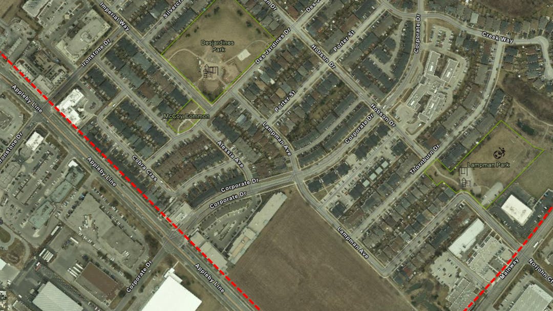
Share In the initial petition and associated Facebook thread, there was repeated references to Alessia, Des Jardins, Hobson, McCoy, and Lampman. All of these roads were NOT covered in the study, but are going to be studies next based on "new feedback." Why were these other streets excluded when there was already feedback? Also - how is Lampman not considered a primary road, when it's one of the main thruways for the entire study area? In fact, it is the main artery for 50% of the physical territory in the study area. The fact that this was excluded in the original study makes the map outlining any part between Corporate and Mainway deceptive at best. on Facebook Share In the initial petition and associated Facebook thread, there was repeated references to Alessia, Des Jardins, Hobson, McCoy, and Lampman. All of these roads were NOT covered in the study, but are going to be studies next based on "new feedback." Why were these other streets excluded when there was already feedback? Also - how is Lampman not considered a primary road, when it's one of the main thruways for the entire study area? In fact, it is the main artery for 50% of the physical territory in the study area. The fact that this was excluded in the original study makes the map outlining any part between Corporate and Mainway deceptive at best. on Twitter Share In the initial petition and associated Facebook thread, there was repeated references to Alessia, Des Jardins, Hobson, McCoy, and Lampman. All of these roads were NOT covered in the study, but are going to be studies next based on "new feedback." Why were these other streets excluded when there was already feedback? Also - how is Lampman not considered a primary road, when it's one of the main thruways for the entire study area? In fact, it is the main artery for 50% of the physical territory in the study area. The fact that this was excluded in the original study makes the map outlining any part between Corporate and Mainway deceptive at best. on Linkedin Email In the initial petition and associated Facebook thread, there was repeated references to Alessia, Des Jardins, Hobson, McCoy, and Lampman. All of these roads were NOT covered in the study, but are going to be studies next based on "new feedback." Why were these other streets excluded when there was already feedback? Also - how is Lampman not considered a primary road, when it's one of the main thruways for the entire study area? In fact, it is the main artery for 50% of the physical territory in the study area. The fact that this was excluded in the original study makes the map outlining any part between Corporate and Mainway deceptive at best. link
In the initial petition and associated Facebook thread, there was repeated references to Alessia, Des Jardins, Hobson, McCoy, and Lampman. All of these roads were NOT covered in the study, but are going to be studies next based on "new feedback." Why were these other streets excluded when there was already feedback? Also - how is Lampman not considered a primary road, when it's one of the main thruways for the entire study area? In fact, it is the main artery for 50% of the physical territory in the study area. The fact that this was excluded in the original study makes the map outlining any part between Corporate and Mainway deceptive at best.
ahall2022 asked almost 4 years agoLampman Avenue was not studied during the initial phase because staff already have previous data on the street. Automatic Traffic Recorders were installed on Lampman Avenue during prior Traffic Calming reviews, both before the speed humps were installed and after. Two locations on Lampman Avenue will be studied during the second phase of data collection to add to the previously collected data to further inform staff and residents. Des Jardines Drive and Hobson Drive had data collected on them during Phase 1. Alessia Avenue, McCoy Avenue and a second location of Hobson Drive will also be included during the second phase of data collection.
-
Share What kind of study result will require contemplating widening of Ironstone and Imperial Way? These are likely large pass-through roads, especially when Appleby and UMR are congested. This will only be more relevant with changes to the Official Plan. on Facebook Share What kind of study result will require contemplating widening of Ironstone and Imperial Way? These are likely large pass-through roads, especially when Appleby and UMR are congested. This will only be more relevant with changes to the Official Plan. on Twitter Share What kind of study result will require contemplating widening of Ironstone and Imperial Way? These are likely large pass-through roads, especially when Appleby and UMR are congested. This will only be more relevant with changes to the Official Plan. on Linkedin Email What kind of study result will require contemplating widening of Ironstone and Imperial Way? These are likely large pass-through roads, especially when Appleby and UMR are congested. This will only be more relevant with changes to the Official Plan. link
What kind of study result will require contemplating widening of Ironstone and Imperial Way? These are likely large pass-through roads, especially when Appleby and UMR are congested. This will only be more relevant with changes to the Official Plan.
ahall2022 asked almost 4 years agoWidening roads would typically be identified in the OP and further would require a planning review to take place such as an environmental assessment (EA). It should be noted that the widening of roads can increase neighbourhood traffic infiltration (cut through) and speeds.
-
Share My understanding is that the current study will be shared with the planning department to be considered with development proposals. What happens to pending development proposals under the new Official Plan? Will they be considered against this study or is it only future development proposals? on Facebook Share My understanding is that the current study will be shared with the planning department to be considered with development proposals. What happens to pending development proposals under the new Official Plan? Will they be considered against this study or is it only future development proposals? on Twitter Share My understanding is that the current study will be shared with the planning department to be considered with development proposals. What happens to pending development proposals under the new Official Plan? Will they be considered against this study or is it only future development proposals? on Linkedin Email My understanding is that the current study will be shared with the planning department to be considered with development proposals. What happens to pending development proposals under the new Official Plan? Will they be considered against this study or is it only future development proposals? link
My understanding is that the current study will be shared with the planning department to be considered with development proposals. What happens to pending development proposals under the new Official Plan? Will they be considered against this study or is it only future development proposals?
ahall2022 asked almost 4 years agoThe Sheldon Creek Neighbourhood Traffic Management Plan and associated data will be shared with the Planning Department. Data from this study will not change the Official Plan as the Sheldon Creek Neighbourhood Traffic Management plan is an in-service road review looking at the existing conditions and concerns in the neighbourhood, whereas the OP provides direction for land-use planning for the city over a 20 year time horizon, and where individual site plan\development reviews allow for the review of specific developments.
-
Share How were the changes to the Official Plan made prior to traffic studies like the one taking place right now? This is another approach to how this study will inform future approval process of development in the area. Why wouldn't this kind of study be performed PRIOR to making the changes now found in the Official Plan because the changes to the OP will inevitably worsen these issues? Seems that in both regards these things are in silos but they should be associated. This is a cart before horse type of thing, but it seems extremely relevant and unclear how/if it's being considered sufficiently. on Facebook Share How were the changes to the Official Plan made prior to traffic studies like the one taking place right now? This is another approach to how this study will inform future approval process of development in the area. Why wouldn't this kind of study be performed PRIOR to making the changes now found in the Official Plan because the changes to the OP will inevitably worsen these issues? Seems that in both regards these things are in silos but they should be associated. This is a cart before horse type of thing, but it seems extremely relevant and unclear how/if it's being considered sufficiently. on Twitter Share How were the changes to the Official Plan made prior to traffic studies like the one taking place right now? This is another approach to how this study will inform future approval process of development in the area. Why wouldn't this kind of study be performed PRIOR to making the changes now found in the Official Plan because the changes to the OP will inevitably worsen these issues? Seems that in both regards these things are in silos but they should be associated. This is a cart before horse type of thing, but it seems extremely relevant and unclear how/if it's being considered sufficiently. on Linkedin Email How were the changes to the Official Plan made prior to traffic studies like the one taking place right now? This is another approach to how this study will inform future approval process of development in the area. Why wouldn't this kind of study be performed PRIOR to making the changes now found in the Official Plan because the changes to the OP will inevitably worsen these issues? Seems that in both regards these things are in silos but they should be associated. This is a cart before horse type of thing, but it seems extremely relevant and unclear how/if it's being considered sufficiently. link
How were the changes to the Official Plan made prior to traffic studies like the one taking place right now? This is another approach to how this study will inform future approval process of development in the area. Why wouldn't this kind of study be performed PRIOR to making the changes now found in the Official Plan because the changes to the OP will inevitably worsen these issues? Seems that in both regards these things are in silos but they should be associated. This is a cart before horse type of thing, but it seems extremely relevant and unclear how/if it's being considered sufficiently.
ahall2022 asked almost 4 years agoThe official plan is a strategic document that outlines the city's land-use strategy over a 20 year time horizon and is prepared to ensure that future planning and development meets the needs of the city. Through the development of the Official Plan, mobility policy is developed which helps guide how people and goods will move throughout the City for years to come. Strategic transportation plans like the Integrated Mobility Plan (IMP) examine the transportation network and recommend strategies and improvements to accommodate future travel demands of our residents. Operational studies like this Neighbourhood Review is conducted on a smaller scale and focuses on studying existing traffic issue on local streets.
Transportation Services works closely with Community Planning throughout the development review and approval process, and we will be sharing the results of this Neighbourhood Review with our internal stakeholders. Data collected throughout this review will augment technical studies submitted by area developers. Recommendations for the Sheldon Creek neighbourhood will aim to create more livable and safer streets. Any forthcoming recommendations will also serve to reduce traffic impacts and infiltration from future developments.
Signup Banner
Who's Listening
-

Email chris.king@burlington.ca -

Key Dates
-
Survey opens- June 8, 2022
Sheldon Creek Neighbourhood Traffic Management has finished this stageEngagment survey opens where you can share any specific issues and/or an areas of concern in the Sheldon Creek Neighbourhood. Your comments will help Burlington develop a Traffic Management Plan that addresses safety issues and resident concerns in your neighbourhood.
-
June 16, 2022
Sheldon Creek Neighbourhood Traffic Management has finished this stageVirtual Public Information Meeting
7:00 - 9:00pm
-
June 27, 2022
Sheldon Creek Neighbourhood Traffic Management has finished this stagePin the map, survey and Q & A closes
-
Spring Engagement
Sheldon Creek Neighbourhood Traffic Management has finished this stageVirtual Public meeting- March 2023
-
March 9, 2023 - PIC # 2
Sheldon Creek Neighbourhood Traffic Management has finished this stageJoin staff for the second PIC to talk about this project and the next steps
When: Mar 9, 2023 07:00 PM Eastern Time (US and Canada)
Topic: Sheldon Creek Neighbourhood Traffic Management PIC
Register in advance for this webinar:
https://us06web.zoom.us/webinar/register/WN_ipjih3-bQLWN95KuhMck5A
After registering, you will receive a confirmation email containing information about joining the webinar. -
Feb 5, 2024
Sheldon Creek Neighbourhood Traffic Management is currently at this stageFinal report presented to City Council at Committee of Whole meeting
Requests to delegate to this meeting can be made by completing the online delegation registration form at www.burlington.ca/delegate(External link), by submitting a written request by email to the Office of the City Clerk at clerks@burlington.ca(External link) or by phoning 905-335-7600, ext. 7481 by noon the Friday before the meeting is to be held.
Document Library

Level of Engagement
- Inform
- Consult
Follow Project
Videos
-
Click here to play video June 16 PIC meeting